Climbing Mount Zeus on Naxos
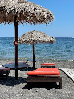
How could we resist the opportunity to stand on the highest point in the Cyclades? Actually, at first there was no appeal - I was more driven to experience the beaches in Greece, not the hikes. It is the thought of sharing the beach with the Meltemi wind that convinced me otherwise.
Mount Zeus was named by the ancient Greeks who believed the Olympian Zeus, god of the sky and thunder, was born and raised in a cave on the mountain. How impressive a claim to fame is that?! I have to admit, it is pretty cool to be in Greece and touching Greek mythology.
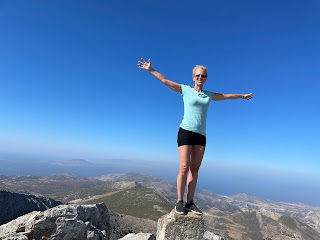
Standing on the pillar that marks the highest point of Mount Zas (Mount Zeus) - 3294 feet above sea level with 360 degree views of the Aegean Sea and surrounding islands.
You can hike the 5 miles round trip to the top of Mount Zeus in about 3+ hours. There are actually two trails that get to the summit: the Aria Spring/Cave of Zas trail and the easier Aghia (Agia) Marina trail.
You want to get an early start in the summer months because there is no shade at all on the hike. At 7:30 am, we took the first bus leaving the port. I had checked the schedule at the bus station the day before, and they told us to buy our round trip tickets (€6 R/T each) the day prior since the office wouldn't be open yet so early in the morning.
The central bus station along the port near the Portara
You can grab the current Naxos local bus (KTEL) schedule from the bus station
You cannot buy tickets on the bus!
Two sisters in line in front of us tried to buy a ticket on the bus. The driver said something, and one of them took off running down the street, presumably to a travel agency? Nothing along the port appears open but she came back with two tickets.
The schedule we picked up from the central bus station in the port shows the bus stop we want for the trailhead: "Agia Marina (Zas Mount)". That is a little deceptive. After a 45 minute ride and passing the village of Filoti, the bus stopped at "Mount Zas".
The bus stop for Mount Zas
A handful of hikers got off. I thought it was our stop too but on my way off I asked the driver which direction do we head to Agia Marina? And he said to stay on the bus. This stop was for the more difficult route. He then drove a short bit further (2.2 km) and dropped us off in what felt like the middle of nowhere, where there is nothing but goats wandering around!
To get to Agia Marina, the bus driver dropped us off along a curve in the road - with nothing in sight but goats. Tip: since buses don't always stop at every stop along the route, inform the driver of your destination so he makes a stop there.
From there, you want to walk up the street towards Monastery Fotodotis. After about five minutes you will see a tiny chapel on your right - Agia Marina church. This is the beginning of the easier route. There is a sign there telling you about the hike to the mountain top. This trail route is simple to follow all the way to the summit especially with all of the trail markers and cairns (man-made rock piles marking the way). However, if you just keep heading up you will get there.
Agia Marina chapel - the start of the easier route
The sign at Agia Marina chapel telling you which way to go
Right behind the chapel you have to go through the gate to get to the trail. The sign on the gate says, "Public Route. Please after your pass close the fence gate behind you."
Great views of the sea and surrounding islands will follow you for much of the way. The old rock walls served as property lines in ancient times.
It is a long, gradual incline to the top through the dry, barren landscape - typical of the Cyclades Islands.
For the last few hundred feet, the two trailers merge and you carefully traverse the jagged, protruding rocks.
On the way back we made a quick decision to try the harder trail for our return - a split route is the perk of taking the bus. The harder trail has been described as "not fun". Though not regretting our decision, we do agree. Take this route if you are looking for some never ending, steep rock scrambling!
"I'm having a blast," stated Jeremy - he had such a positive attitude about our adventure.
Marked as "difficult", the easier way up was about half the difficulty of Upper Yosemite Falls. The harder route was way worse. We wondered how the heck the small children we passed made it up this treachery.
"Are we even on the trail anymore?" Greg asked, unknowingly standing right next to the trail marker.
The more interesting, steep route - does this look fun? You are headed straight up the ravine and up to the tippy top of that mountain!
If you want to see Cave Zas you have to hike the harder route
We only went a few feet into Cave Zas but you can go quite a bit further - it reaches 115 meters high and 75 meters wide and has impressive stalactites and stalagmites.
The harder trail just didn't seem to end, and wasn't getting any easier. Finally we hit a paved path. I recognized it from my research, thinking it was where we wanted to go - but the goat gate looked private and uninviting. Trying it anyway, I realized it was definitely the right way to Aria Spring, which has a natural spring of drinking water, and the parking area for the harder route.
If you are hiking up the more difficult route, at the end of the paved path is where the going gets tough. Commit or turn back here.
Aria Spring is cool and refreshing - and drinkable!
At this point, with 2 hours and 45 minutes til the bus would pick us up, it didn't make sense to finish our hike. At Aria Spring, Greg and his map spotted a trail to Filoti so we took that. Clearly it is not well-traveled.
At Aria Spring you can take this trail to Filoti
The trail to Filoti was easy to follow but looked a bit overgrown and unused
We had to untie several gates to open them on the trail to Filoti
Just stepping off the trail to Filoti, I think it would be hard to find in reverse
Jeremy and I particularly enjoyed our adventure. I tried to plan something like it from home but couldn't google enough details so gave up. I think it would be confusing in reverse because both the Filoti trail and difficult route are a lot harder to follow. But with this information I think you can figure out how to do what we did.
Chris' watch said we hiked a little over 5 1/4 miles. The easy route up and the difficult route down took us exactly 3 hours.
I wouldn't recommend this hike without a map app - especially if you are trying to stay on the easier route, which is visible on the map app. For the past six years we have used City Maps 2 Go for all of our travels but suddenly during Covid, they erased our hundreds of traveling pinpoints through all of the countries we have visited - including the ones I had recently put in for Greece. So we switched to Maps.Me. With it, Greg was able to keep us reasonably on the right path, with the exact location off only a few times - but in those cases it was always obvious which way was correct by the trail markers.
Filoti is a small mountain village at the base of the mountain. There are several nice outdoor restaurants here to catch a bite to eat after the trek. When we sat down at welcoming and completely shaded Platanos Cafe in Filoti to wait 2 hours for our bus, I asked Jeremy if treasure like this (the pretty town and scenery/good food/ friendly waiter) make him like this island better. "Things like walking onto this island make me like this island better," he responded.
Save time after the hike for a drink or lunch at Platanos Cafe in Filoti. It was a relaxing end to a great hike. We waited here to catch the bus - the bus stop is under the tree.


Comments
Post a Comment